/roadweather
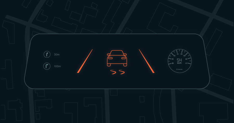
For essential information on road conditions through a summary index (green, yellow, or red), enabling users to gauge driving safety at a glance.
Real-time and forecast road surface conditions for automotive applications, delivered through the Weather API.
:focal(1773x2154:1774x2155))
Vaisala Xweather provides a weather API that delivers forecasted road surface conditions. This includes dry, wet, slush, snow, and ice classifications, along with road surface temperature and sub-millimeter water, snow, and ice depth. The API returns probability values for each surface condition, giving developers confidence-level data for decision logic in ADAS and driver-warning systems.
This data is already in production use in luxury and premium vehicles, where accurate road condition awareness is critical for safety, comfort, and advanced driver assistance. As vehicle automation and regulatory safety requirements evolve, forecasted road weather is expected to become a foundational input for future vehicle safety standards.
Road weather data is engineered for developer integration into in-vehicle systems, automotive navigation stacks, and mapping and planning engines. Coverage spans millions of kilometers of roads across North America, Europe, Japan, South Korea, Australia, and New Zealand, with primary roads, secondary roads, and bridges modeled separately.
)
Wet conditions account for nearly three-quarters of all weather-related road accidents. Even a small amount of water on the road surface reduces grip, and the risk of aquaplaning increases rapidly with heavy rainfall.
Identify dry and wet road conditions
Water film thickness
Snow is a common winter road hazard, causing 17% of weather-related accidents in northern parts of Europe and North America. Unlike water, snow can be present on the road for long periods.
Identify snow and slush road conditions
Snow depth
Ice typically forms on roads when low temperatures turn morning dew into frost or freeze standing water on the pavement. Although ice is less common on roads than water and snow, it is far more dangerous for drivers.
Identify icy road conditions
Ice thickness
For essential information on road conditions through a summary index (green, yellow, or red), enabling users to gauge driving safety at a glance.
For the complete road weather offerings, the Road Weather Analytics endpoint adds water, snow, and ice thickness, hydroplane and turnover probabilities, visibility probabilities, and more.
For comprehensive road weather insights, including the road surface condition (dry, wet, snow, ice) and road surface temperature.
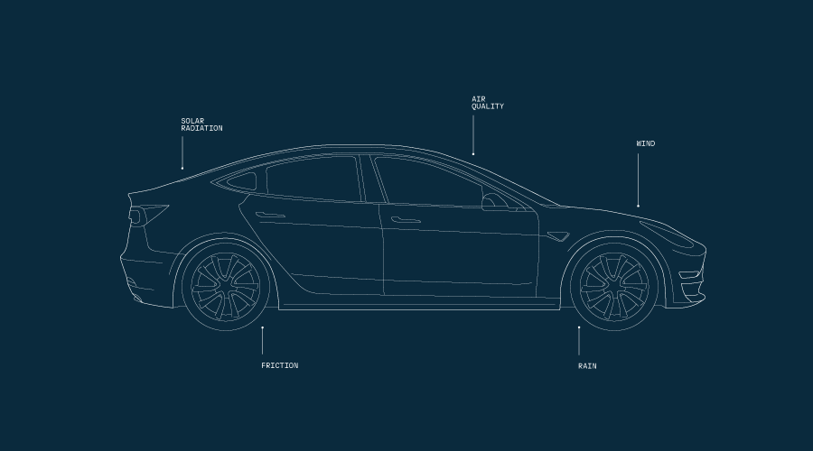
Road weather data is powered by a proprietary network of road weather sensors, high-quality data sources, and algorithms that predict how environmental conditions affect the pavement.
Precipitation, solar radiation, traffic, maintenance activities, and the physical attributes of the road all feed the model.
Machine learning combines these inputs to produce a nowcast that updates every 15 minutes and a 24-hour forecast for longer trips.
)
The road weather model accounts for all processes that add and remove water, snow, and ice from the road surface. Forecasts are continuously refined by validating model output against ground-truth measurements from road weather stations and mobile sensors.
The modeling behind road weather data draws on 85+ years of Vaisala sensor development and more than 30 years of road weather forecasting. Xweather works with top-tier vehicle manufacturers and automotive technology companies worldwide to improve driver safety, comfort, and convenience.
)
Millions of kilometers of road covered
Primary and secondary roads across North America, Europe, Japan, South Korea, Australia, and New Zealand.
15-minute update interval
Real-time conditions and forecasts for every public paved road in the coverage area.
30+ years of road weather forecasting
Developed alongside road safety professionals and top-tier vehicle manufacturers worldwide.
Million-kilometer validation dataset
Ground-truth sensor data used to train and validate the road weather model.
RESTful service providing precise road weather data
Example request
Response
Our software development kits for iOS, Android, and JavaScript make it easy to integrate Xweather data into your apps and platforms—with the tools you need to move from prototype to production.
Integrate road weather data into AI workflows with direct API access through the Xweather MCP server. Query, analyze, and act on road surface conditions for automated decision-making.
Build agents that access road weather intelligence through the Xweather MCP server. Real-world road surface conditions integrate directly into AI and LLM workflows.
)
The MapsGL vector mapping platform renders road weather data on interactive maps for dashboard integration, navigation overlay, and development environments. Customizable layers and full branding control.
)
MapsGL uses WebGL for smooth, data-driven weather animations. Mapping layers are optimized for low-bandwidth use and fully customizable for branding and styling.
Raster Maps is a tile-mapping tool for still-image weather visualizations, with 100+ layers compatible with Mapbox, Google Maps, and Leaflet.
Explore real-time lightning strikes, wildfire boundaries, road weather data, and more in the Xweather browser-based weather app. A live view of what the maps and API can do.
)
The most unique datasets in the market, backed by high-resolution, real-time data from a globally distributed proprietary infrastructure.
Road weather data is included in the Weather API and Maps subscription, with access to all road weather endpoints and high-resolution visuals via Raster Maps and MapsGL.
)
)
)
Surface state (dry, wet, snowy, icy), grip, surface temperature, water film thickness, snow depth, ice thickness, visibility, and probability values for water, snow, and ice presence.